This page is part of © FOTW Flags Of The World website
Steenwijkerland (Netherlands)
Overijssel province
Last modified: 2006-12-09 by jarig bakker
Keywords: steenwijkerland | steenwijk |
Links: FOTW homepage |
search |
disclaimer and copyright |
write us |
mirrors
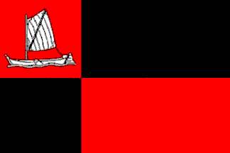
![[Steenwijkerland flag]](../images/n/nl-ov-sl.gif) by Mark Sensen, 4 Mar 2003
by Mark Sensen, 4 Mar 2003
adopted 18 Feb 2003
Other Steenwijkerland pages:
See also:
Steenwijkerland municipality
Number of inhabitants (1 Jan 2003): 41.867; area: 330,00 km². Settlements:
Steenwijk
(seat), Baarlo, Baars, Barsbeek, Basse, Belt-Schutsloot, Blankenham, Blauwe
Hand, Blokzijl, De Bult, De Klosse, De Kolk
(ged), De Pol, Doosje, Dwarsgracht, Eesveen, Giethoorn, Heetveld, IJsselham,
Jonen, Kadoelen, Kalenberg, Kallenkote, Kuinre, Leeuwte, Marijenkampen,
Moespot, Muggenbeet, Nederland, Oldemarkt,
Onna, Ossenzijl, Paasloo, Roekebosch, Ronduite, Scheerwolde, Sint Jansklooster,
Steenwijkerwold, Tuk,
Vollenhove,
Wanneperveen, Wetering, Willemsoord, Witte
Paarden, Zuidveen
Steenwijk is the result of a merger of the former municipalities of
Brederwiede,
IJsselham
and Steenwijk (1 Jan 2001), the flag is provisional and
is of the former municipality of Steenwijk.
Wanneperveen
became part of Brederwiede in a merger in 1973, and Steenwijkerwold
was split up among all three former municipalities. The municipality was
renamed on 1 Jan 2003 to Steenwijkerland.
The municipality of Steenwijkerland in the beautiful northwestern corner
of the province, hemmed in by Fryslân, Drenthe and Flevoland, adopted
on 18 Feb 2003 a new municipal flag: the municipal logo on a white field;
how it looks when there's no wind: see this
webpage. No new CoA adopted yet.
Jarig Bakker, 25 Oct 2003
Brederwiede [former municipality]
 Shipmate Flagchart : http://www.flagchart.net
Adopted 12 Feb 1974
Steenwijk [former municipality]
 Shipmate Flagchart : http://www.flagchart.net
Adopted 25 Mar 1982.
![[Steenwijkerland flag]](../images/n/nl-ov-sl.gif) by Mark Sensen, 4 Mar 2003
by Mark Sensen, 4 Mar 2003

![[Steenwijkerland flag]](../images/n/nl-ov-sl.gif) by Mark Sensen, 4 Mar 2003
by Mark Sensen, 4 Mar 2003
 Shipmate Flagchart : http://www.flagchart.net
 Shipmate Flagchart : http://www.flagchart.net