This page is part of © FOTW Flags Of The World website
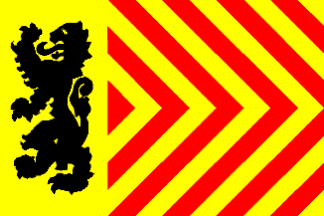
Langedijk (The Netherlands)
Noord-Holland province
Last modified: 2006-12-09 by jarig bakker
Keywords: langedijk |
Links: FOTW homepage |
search |
disclaimer and copyright |
write us |
mirrors
 Shipmate Flagchart : http://www.flagchart.net
adopted 8 Mar 1980
Other Langendijk pages:
See also:
Langedijk municipality
Number of inhabitants (1 Jan 2003): 24.981; area: 26,99 km². Settlements:
Zuid-Scharwoude (seat), Broek op Langedijk, Koedijk (part), Noord-Scharwoude,
Oudkarspel, Sint Pancras.
On 1 Aug 1941, ordered by the German occupational forces, four villages
merged: Oudkarspel, Noord-Scharwoude, Zuid-Scharwoude and Broek op Langedijk
became one municipality. In 1990 Sint Pancras
and part of Koedijk also became part of Langedijk.
Langedijk CoA
![[Langedijk CoA]](../images/n/nl-nh)ld.gif) image from Ralf hartemink's site.
image from Ralf hartemink's site.
Granted 1 Jun 1944.
 Shipmate Flagchart : http://www.flagchart.net

 Shipmate Flagchart : http://www.flagchart.net
![[Langedijk CoA]](../images/n/nl-nh)ld.gif) image from Ralf hartemink's site.
image from Ralf hartemink's site.