
This page is part of © FOTW Flags Of The World website
Oldebroek (The Netherlands)
Gelderland province
Last modified: 2006-12-09 by jarig bakker
Keywords: oldebroek |
Links: FOTW homepage |
search |
disclaimer and copyright |
write us |
mirrors
 Shipmate Flagchart : http://www.flagchart.net
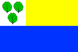
unofficial flag
See also:
Oldebroek municipality
Number of inhabitants (1 Jan 2003): 22.904; area: 98,78 km². Settlements:
Bovenveen, Eekt, Hattemerbroek, Kerkdorp, 't Loo, Mullegen, Noordeinde,
Oldebroek (seat), Oosterwolde, Posthoorn, Voskuil, Wezep.
Oldebroek is in northwest Gelderland in the Veluwe region. The name
is derived from 'Hollanderbroek', wetland reclaimed by Hollanders
(inhabitants of the Holland region) in the 12th century AD. The municipality
got its present borders in 1974. Many a Dutch youngster served here in
military barracks.
The leaves in the canton have been taken from the CoA; they are alder
leaves (elzebladeren). The flag has not been officially adopted;
it consists of two equally wide horizontal stripes. The bottom stripe is
blue. The top stripe is yellow, with a square canton with the municipal
arms.
Jarig Bakker, 9 October 1999
Oldebroek CoA
![[Oldebroek CoA]](../images/n/nl-ge)ol.jpg) image from this website.
image from this website.
Granted 2 Jul 1855.