image by Jaume Ollé, 28 March 2005

Last modified: 2007-07-28 by dov gutterman
Keywords: guatemala | chimaltenango |
Links: FOTW homepage |
search |
disclaimer and copyright |
write us |
mirrors

image by Jaume Ollé, 28 March 2005
See also:
Municipalities:
Other sites:
In Bulletin Flag Report 8 appeared various departmental flags
of Guatemala and all the coat-of-arms. With some delay it was
received by mid October the communication from the departmental
governor of Chimaltenango Jorge Morales Muńoz dated on 11
September (month of the country's independence) 1998, but written
on 9 September 1998. The redaction was made in fact by Francisco
A. Colindres G., first officer of the government of
Chimaltenango, and the picture of the flag that accompanies the
communication was made by Jaime Bal Sotz, of the 3rd operative of
the government.
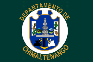
Dark green rectangular flag, with bright yellow fringes in the
borders, containing a white circle with the departmental
coat-of-arms. Green symbolizes the people of the department
living in democracy, faith and hope. White symbolizes purity,
quietude, honesty, peace, integrity, firmness and light offered
by its inhabitants.
Coat-of-arms: Represents the union of 16 municipalities
(Acatenango, Chimaltenango, El Tejar, Parramos, Patzicia, Patzun,
San Andrés Izapa, San José Poaquil, San Juan Comalapa, San
Martín Jilotepeque, San Miguel Pochuta, San Pedro Yapocapa,
Santa Apolonia, Santa Cruz Balanya, Tacpan Guatemala and
Zaragoza).
Blue in the coat-of-arms symbolizes justice, loyalty, truth and
the strength of its inhabitants, as well as the sky of the
department in the summer months, and the seas surrounding
Guatemala; the country is represented by the flag in the upper
part.
The lyre is in honor of the great musician Rafael Alvarez Ovalle,
author of the music of the national anthem (one of the most
beautiful of the world), and also in honor of all the musicians,
guitarists, pianists, harp, drum, chirimilla players, and the
great marimba composers and players of the department, since the
marimba is the wild piano that puts happiness between the sky and
the earth, and with it the people of Chimaltenango get in
communion with God, with the heart of the sky and the heart of
the land, since it is said that in Chimaltenango the marimba
weeps and sings, and when it sounds with a pair of drumstick
strokes and people dances, their pain is scared away.
The colonial fountain is placed in the central park of
Chimaltenango, head of the department, and unites both oceans
with its drains: one that goes to the Pacific and the other to
the Atlantic.
The swans represent the resort "Los Aposentos" of
Chimaltenango, where they live since several years, and it is the
tourist attraction for nationals and foreigners.
The wheat and the corn, represent since thousands of years the
main crop and the hard work of the men of the department. The
coffee, grown in the department, mainly in the municipalities of
Acatenango, San Pedro Yepocapa and San Miguel Pochuta, is
classified as one of the best of the world. These products have
been chosen to appear in the coat-of-arms but in the department,
a little bit of land blessed by God, a great quantity and variety
of fruits, vegetables, corn, wheat, potato and bean is grown, and
ancient and modern handicraft is produced; bricks and tiles are
made in the prosperous municipality of El Tejar that provides all
the department of Chimaltenango. Thanks to its climate (the best
of the world) all kind of animals are raised, represented also in
the coat-of-arms, mainly cattle, horses, mules, sheep, goats and
other.
In the two circles flanking the colonial fountain are shown the
ruins of Iximche, in the municipality of Tecpan Guatemala, pride
of the department; Tecpan Guatemala is the first colonial city,
cradle of the Mayan civilization of the kakchiquels, and Iximche
was the first capital of the ancient Mayan kakchiquel territory,
being now the "archaeologic center Iximche"; its
history goes back to the Spanish conquest and colony. In the
other circle are placed the fire volcanoes of the municipality of
Acatenango, that represent together with the nearby mountains,
the parapet put by God and mother nature to protect the nearby
municipalities of San Pedro Yepocapa, Acatenango, Patzicia,
Zaragoza Parramos, San Andrés Itzapa, El Tejar and properly the
departmental head Chimaltenango, from the hurricane winds that
come from the Southern Coast (Pacific Ocean) and saves the
municipality of San Miguel Pochuta -by its topographical location
already part of the coast- in the months of November, December
and January from the frosts that could kill the crops.
Chimaltenango is a word of Mayan origin. Chimal means
"shield" or "wall" and tenango means
"hill". The kakchiqueles called it Bocob. The modern
city was founded by Pedro Portocarrero in 1526, only two years
after the Spanish established in the capital of the Kakchiquel
Kingdom, Iximche (25 July 1524), renamed Guatemala (today Antigua
Guatemala). In the 17th century it was called Santa Ana
Chimaltenango, and was a prosper an important town. In the 18th
century it constituting the corregimiento of El Valle, dependent
of the city of Guatemala, and it was destroyed by an earthquake
on 29 July 1773. The title of Alcaldía Mayor (Greater
Municipality) was granted on 22 November 1782, as capital of the
province of the same name. It was province and department
recognized by the successive administrative divisions of the
country. The title of city was granted in 1926.
Jaume Olle', 28 March 2005
cm.gif)
image by Jaume Ollé, 28 March 2005