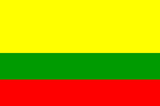
image modified from wikipedia, located by Felipe Carrillo, 3 April 2008

Last modified: 2008-08-16 by dov gutterman
Keywords: cauca | almaguer |
Links: FOTW homepage |
search |
disclaimer and copyright |
write us |
mirrors

image modified from wikipedia,
located by Felipe Carrillo, 3 April 2008
See also:
The municipality of Almaguer (21,812 inhabitants in 2003;
3,104 inh. in the town of Almaguer proper; 320 sq. km) is located
170 km east of Popayán.
On 10 October 1550, Briceño, Deputy Governor of Popayán,
allowed Vasco de Guzmán to set up a pacification and settlement
operation. Together with 59 men, Guzmán founded the settlement
of Ciudad del Cesar, located 2,300 m a.s.l. The
nefarious Alvaro de Oyón, coming from Peru like Guzmán, was
appointed Mayor of the new settlement. Eventually sacked
following complaints and desertion by the colonists, Oyón was
replaced by Alonso de Fuenmayor, appointed Governor on 14 July
1551. Fuenmayor refounded the settlement and renamed it Almaguer,
as a tribute to Briceño, who came from Almaguer, Mancha, Spain.
The tradition says that the refoundation ceremony took place on
19 August 1551, on St. Louis' Day. However, this
"tradition" seems to have been fabricated in the
XVIIIth century, when the name "San Luis de Almaguer"
was given to the settlement, as a tribute to Louis, son of King
Philip V.
Proclaimed "Mining District of Spanish America" (Distrito
Minero de la América Española), Almaguer was granted a
coat of arms and the title of "Very noble and lawful
town" ("Muy noble y muy leal ciudad")
by King Philip II.
The flag of Almaguer is horizontally divided yellow-green-red
(2:1:1). Yellow symbolizes richness, green symbolizes the
environment, the flora and the fauna, while red symbolizes the
blood shed by the liberators.
Source: Municipal
website.
Ivan Sache, 20 July 2008